"Chelan Trophy"
Written by Tom Morse
 |
It was raining, foggy and my gun was wet and the scope was covered with condensation on the outside of the lenses. It was a Leupold Vari X II, 3 by 9. I hoped it was clear enough to peer through for a good shot. I wasn't confident enough for a shot at 350 yards, so I dropped my Stetson and began crawling through the wet blue berry plants and the mountain heather. Between me and the buck was a deep ravine slick with heather and blueberry plants making for a difficult, but hidden route for a closer shot. I stumbled as I traversed down the embankment to the bottom of the ravine and slipped as I tried to crawl up the other side. It was steep. I grabbed at small roots and heather as I slowly made my way up the other side.
Eventually the blueberry plants grew taller and taller, so I had to part them to get another look at the huge buck. As I peered through the brush, I notice a doe had me in her sights dead to right, I froze, had the buck seen me as well?, I thought.
I dropped slowly like a school boy being caught smoking in the lavatory. Then slowly rose, eyes searching for the buck. Finally, I stood erect in full view of the doe, my fears came true, the buck had me in his sight head down staring right at me��� It was now or never.
The date was September 15, the day I was supposed to be up in the wilderness on my annual trek to find the elusive and majestic mule deer Stag. The usual route was blocked because of a forest fire somewhere up the Chiwawa River road. From that trail head called Trinity, at the end of the road, it was about a ten mile ride through a beautiful lower elevation valley. It started at an old mining community; you crossed Buck Creek on a bridge and headed up the valley towards higher ground and into the Wilderness of Washington State.
The weather was as unpredictable as a land mine in this wet most northwestern state. This year had been a very dry year with extreme fire conditions, which also made for poor hunting conditions for mule deer as the hot dry weather spawned hornets and too many insects in the high country to count. In these dry conditions, the deer are driven into the lower heavily wooded areas where they could lay in the brush near the creek bottoms and enjoy cool fresh air and relief from all the bugs. I was kind of caught off guard by the closure, so didn't go for the opening day. I hesitated, not knowing where to go. My only option to get to Buck Pass was now to go twice as far as usual, twenty miles instead of ten.
We would have to launch from the Suattle River trailhead and traverse across an unknown trail called Middle Ridge trail. This trail was known well by Icicle Outfitters who used it on occasion to pass through it to do some drop camps either on Middle Ridge or further. It was known to be narrow, steep and not well maintained in some places. I wasn't sure if I wanted to try risking a wreck packing my horses through there. My horses are like beloved pets, family members to me. Bringing with them memories of many beautiful pack trips hunting and fishing, along with a few wrecks which I will avoid at all cost.
After having talked to Icicle Outfitters, the Forest Service, and others familiar with the trail, I was on my way.
The date was September 16th as we headed up Suattle River road planning on camping at the trail head and getting an early start the next morning as the trip was a long one and I didn't like pushing the horses very hard. We were going camping and I want them to have a good time too. For fun, we took a � mile side trip crossing Milk Creek trail just to look at it on the way up. It was a well built bridge heading towards the top of Glacier Peak, a secondary route for climbers who wanted to traverse the volcanic peak into Washington's Glacier Peak Wilderness. As we arrived at the trail head we set up a tent and climbed in. It was just getting dark and the horses were high lined and fed.
As daylight broke, we arose and began preparing for the long ride. Again not wanting to push my horse too much, we took our time getting ready. We lead the horses to water, fed them, and then fed ourselves hot cakes and bacon for breakfast. We made sure our water bottles were full and did an inventory on all of our equipment to make sure we weren't missing anything. We hit the trail at about 11:00 am, starting our long winding ride to the halfway point known as Skyline Bridge, where the trail crossed the raging, unforgiving, always grey with volcanic ash laden waters of the Suattle River.
The trail begins near sulphur hot springs, as you approach the trailhead you cross a bridge going over Sulphur Creek and the aroma of sulphur is thick in the air. The first � mile of the trail is a logging road which was doomed my Teddy Roosevelts Wilderness act way back when, and then you wind your way up along the raging Suattle River. Horses and mules have fallen off this trail before as it is very narrow and treacherous. One such story made headline news as the horse apparently fell in the river, swam down stream a ways and climbed up onto the opposite bank. It took days for the owners to get their horse back on the trail. So, we made sure our panniers were balanced and all the cinches were good and tight.
Through this lower stretch of the trail you pass some old growth firs, nobles, Douglas fir, Grands, and Western Red Cedars. Some of which are 8 or 9 feet straight through. Very massive and majestic these trees, kind of reminds me of Theodore Roosevelt, as he was their savior. You also find lots of Oregon grapes ferns, devils clubs, pacific yew and some blueberries in this section of the trail. It seems to wind on endlessly, huge cedar after fir after hemlock as you wind along the precipitancy narrow trail along the whitish ash laden Suattle River. I have been up here many times, each time seems to bring new adventure and peril. The trail seems to relate to all the senses, as you smell the firs, cedars, and fresh moist air next to the damp moss covered forest floor. The sound of the hoof beats, squeaking leather saddles, the wind in the trees and all of a sudden the silence is broken by low flying EA6B jets from the Whidbey squadron flying below radar in an endless practice for precision in readyment for any threat to this great nation. The horses kind of tighten up as the jets approach, but then relax as if to say, "Oh, I remember those things, they aren't so scary.."
After about 7 miles, you climb up the ridge away from the Suattle a bit, so you can't even hear its roar. Suddenly, you slowly near a roaring creek known as Canyon creek, draining out of Canyon Lake high on Miners ridge. One of my favorite bridges is this cable and wooden suspension bridge hanging 30 to 40 feet over canyon creek. I always like getting to this point, it is kind of the quarter point of the ride towards the top of Suattle pass.
Finally, we reached Skyline Bridge which still existed in 2003. We camped the night and then headed up middle ridge trail until we reached the turn off which is the part of the trail I had in question in my mind. The last time I tried to take this route, my mustang, Brittany, got stung by hornets living in the soil beneath the trail and started bucking. I retreated that time not knowing how far the trail went in that direction.
This time we were determined to get through, and get through we did. It was quite a narrow, slanted and over grown trail at the time. About 5 miles worth of wet brush, fog and a constant drizzling rain upon us. We finally reached the switchbacks just below Buck Pass and wound our way up to the top. This section of the trail was terrible. Steep, narrow, slanted and covered with heather bushes and roots.
We made it safely with the help of my experienced and sure footed trail horses. Brittany, a born wild mustang, Rose, a purebred appy mare, and Luke, a monstrous muscular black quarter horse gelding.
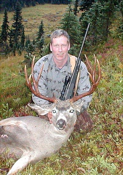
I can't say our adventure was near an end at this point, as we were wet, cold and had no dry firewood. We eventually got a fire going, the tent up, and I decided to take my walk behind camp. As mentioned earlier, I had been spotted after crawling 100 yards or so to be within I would say 200 to 250 yards of the buck. I had been spotted and it was now or never. As I brought my scope up to my eye, it was foggy, the seals had failed in my scope. I'd had that scope for years and did on occasion break the rules of putting my scope near a heater to dry my gun off. The abuse was about to cost me dearly as I could barely make out the outline of the deer in my scope. Just a big wet blur. I finally chose to shoot dead center of the fuzzy shape of the deer. The thunder of the Tikka 300win magnum was defining as the round sliced through the crisp moist air�.I peered up the slope at the buck and he was still looking at me. I misled wondering if had hit him or if he was just wondering what that noise was? So I drew down on him again, the buck moved forward a few steps and this time I tried to shoot closer to the front end of the deer hoping for a vital or a spine neck shot. Again the roar of my rife cracked and rumbled through the mountain silence. This time he dropped like a rock and rolled down the mountain about a 100 yards or so to finally come to a rest on the slopes of Liberty Cap.
Click-a-Pic ... Details & Bigger Photos
Click-a-Pic ... Details & Bigger Photos
Videos | Hunts & Tags | About Mule Deer | About Elk
Classified Ads | Photo Tours | About this Site | Advertising |
Older Content | Email Us | Privacy Policy